Deprecated: Unparenthesized `a ? b : c ? d : e` is deprecated. Use either `(a ? b : c) ? d : e` or `a ? b : (c ? d : e)` in /home/papillo7/public_html/wp-content/plugins/wp-structuring-markup/includes/wp-structuring-opening-hours.php on line 192

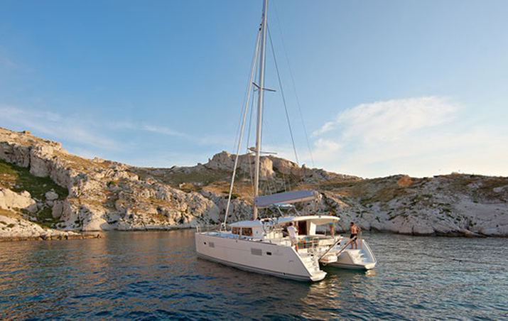
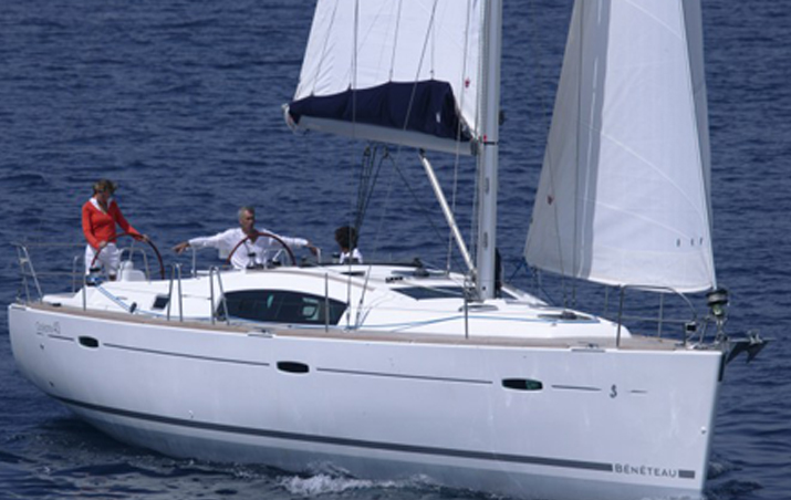
LEARN TO SAIL. Rental boats Ibiza.Para who are lovers of boats and the sea.

Alquile velero Ibiza sunreef dependeIV

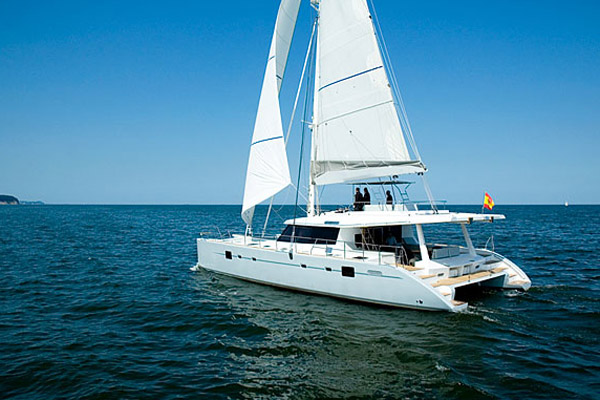
We make this post to encourage them to bring forth permission pattern pleasure craft (PER) a great idea so that you can at any time to rent a boat and enjoy this exciting experience is navigation.

It is a privilege to have absolute independence and not rely on someone so we can see so wonderful at our disposal sites, namely to take control of a boat and have the good fortune to visit places from the sea, which offers views different and special, truly a luxury.

lagoon-400-alquiler-de-veleros

The conditions governing the nautical qualifications of these vessels belong to the Directorate General of Merchant Marine under the Ministry of Public Works of Spain. However, the actions to follow correspond to regions that have assumed the responsibilities in this area.

The course craft pattern is the most demanded by sailing enthusiasts.

REQUIREMENTS FOR OBTAINING

-Have At least 18 years old.

-overcoming A medical examination at approved testing center.

Approving a theoretical examination.

Approving the practical test or to have completed safety practices and navigation of at least 16 hours.

-Make A radio regulatory practices which period shall not be less than two hours, they will be held in classroom, in an approved simulator an approved school.

BASIC SKILLS

Government motor yachts up to 15 meters in length, which enables them to navigate in the area between the coast and a line parallel to it, drawn 12 miles from this.

beneteau-57-alquiler-de-veleros

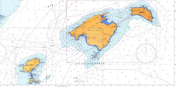
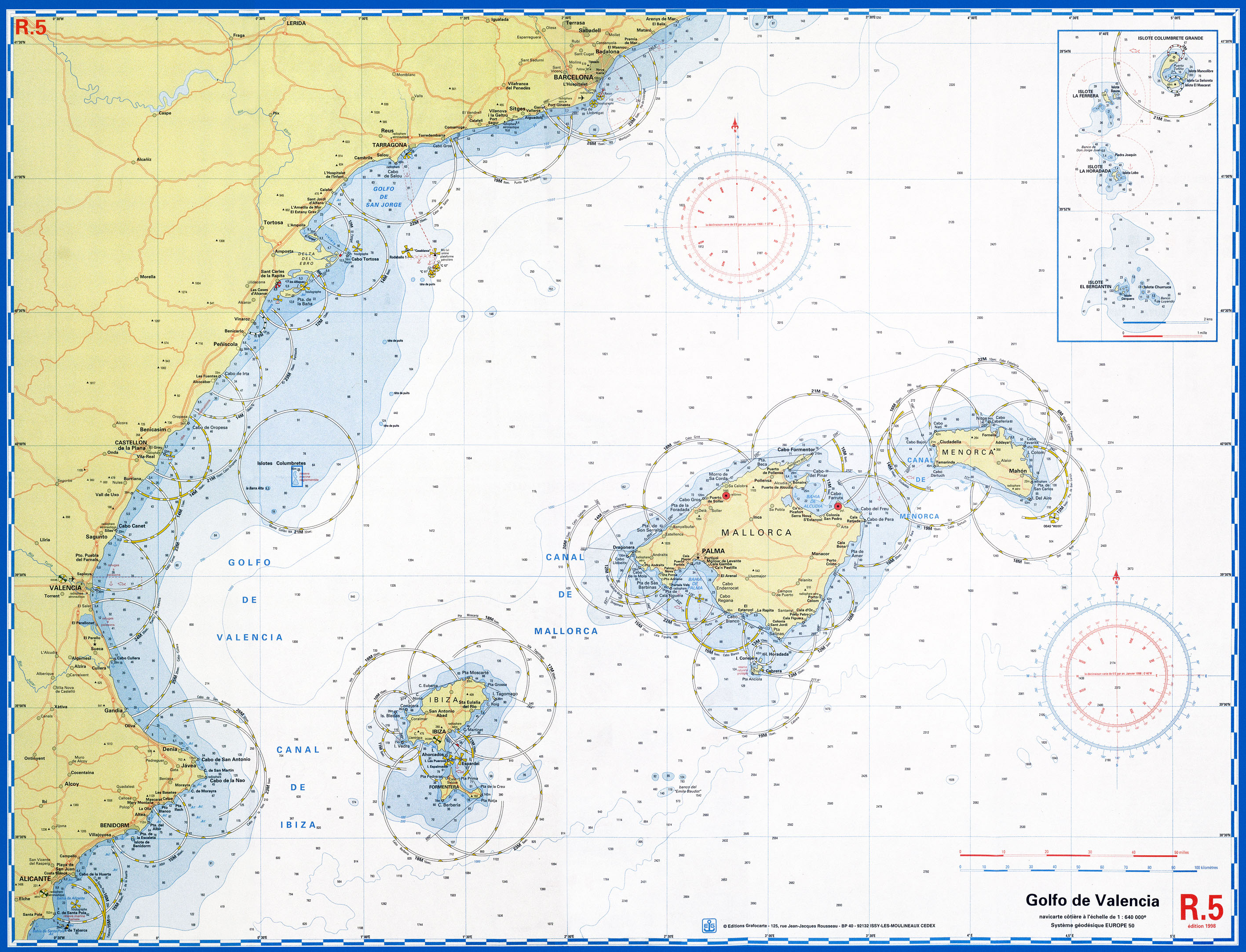
We can also navigate between islands within the Balearic and Canary archipelago.

Government of jetskis, within specific limits applicable to such navigation, according to its technical characteristics.

ADDITIONAL SKILLS

If navigation practices are made they can govern motor yachts up to 24 meters in length and navigate between the Iberian Peninsula and the Balearic Islands.

If sailing practices are carried out, they can govern pleasure boats sailing up to 15 meters in length, or up to 24 meters if they have also made navigation practices

Oceanis 473 Alquiler de Veleros

THEORETICAL REVIEW OF PATRON OF RECREATIONAL CRAFT (PER)

The length of the test will be two hours and thirty minutes. The test will consist of 75 questions and the structure of the exam will be:

Six of naval technology.
Eight of maneuvering engine.
Once security.
Twelve of navigation (four of them on exercises on the chart)
Four meteorology.
Five radio.
Five propulsion.
Fifteen of regulations approaches.
Five beaconing.
Four of legislation.
To successfully complete the examination of this nautical qualifications must correctly answer 70% of questions, you will not be able to make more than two errors in the questions of radio, mechanical propulsion and exercises nautical chart, markings, and no more four in the COLREGs.

BASIC PRINCIPLES OF NAVIGATION

Techniques to move a boat from one side to another are based on geometric and mechanical physical laws.

Knowing our position in a letter is essential, calculating directions and directions, understand the different ways in which time is measured, and the different speeds that are measured on a ship like the SOG or COG.

The nautical chart

The nautical chart is a scale representation of navigable waters and enclosed land regions.

Usually indicates water depths and heights of the terrain, nature of the fund, details of the coast including ports, navigation hazards, location of lights and other aids during our travels by sea.

The letters are an essential tool in cruises, recently there are computer systems that allow the storage and processing of nautical charts with computers.

carta nautica baleares jpg

Carta%20mediterraneo.2 jpg

As we say is very important to position in a letter to this two coordinates, latitude and longitude are used. There are many positions: estimated, GPS, or the true position, to find our position may use such markers compass.

SAILING BASIC MANAGEMENT

The easiest direction to follow is the perpendicular to the wind, this is navigate through.

You have to put the boat perpendicular to the wind, go hunting the mainsheet until the end of the boom protrude slightly through the transom and candles form an angle with the hull of about 45 degrees, if it takes jib, placing the same angle as the greatest.

YACHTING RECKONING

If we move in a known direction and also at a known rate for a while, we can estimate a new position and represent it in a letter. In the reckoning we must take into account the currents, also other deviations that we may know as to optimize our prediction.

For reckoning it is necessary to maintain a course as accurately as possible, and measure the speed is done in each section.

OCEANIS-43-alquiler-de-veleros

Electronic Navigational
We can know our navigation data accurately through electronic devices, GPS, Chart-plotter, radar, loran, transponders and depth gauges.
In the event that we fail to modern devices; by the stars and the sun we can guide us and know our position at sea.
ON THE ANCHOR
In nautical anchor action it is to tie the boat to the seabed by a rope or chain either using an anchor or dead. A mooring buoy with dead and is a permanent device that allows anchoring boats safely.
The elements that compose it are:
The dead, great weight element made of reinforced concrete supported on the bottom where the anchor line states.
The mooring line.
The buoy floating object that provides access to the mooring line.
The mooring line.
The connecting elements: shackles and swivel, these are usually located in a safe place to anchor, which is called anchorage. Retention capacity is proportional to the weight of the dead regardless of the type of bed, and depends on the friction produced with the background, when the dead is half buried, the suction effect increases their holding power.
ANCHOR WITH WIND
In these cases it is necessary to take out that will add to the chain meter anchor line. Cape is suitably nylon is very durable and also acts as a spring for its flexibility. This bending allows the absorption energy due to gusts and so frequent blows of the waves in a storm.
We should not use less than five to six times the depth in the length of the total mooring line, flex nylon eliminate power surges in the bottom of the chain, which helps it to avoid anchor drag, to despite the sudden impulses transmitted by a blow wave or gust of wind.
ANCHOR BOAT
An anchor or anchor is a nautical captive moving object that allows a boat grip fix its position in the sea without having to worry about the current, against the force of the tide.
The anchor mooring usually consists of two or more hooks that are responsible for it clings to the seabed, preventing the ship can be dragged adrift. Small boats have only one, which is attached to the boat by a rope or chain, depending on the length and current regulations.
Larger vessels usually have three, one in the stern and two in the bow, hooked by chains.

bahia-de-kleftiko_402259

THE BOAT AND THE BAD WEATHER

We must reduce sail area order not to endanger the stability of the vessel due to the intensity of the wind.

Jib roll up part of the forestay, or put a smaller headsail.

the surface of the largest folding of the sail on the boom is reduced; It is what is called reefing. If weather conditions are very bad, one option is to hove, thus the ship will be standing on the sea and relatively safe, we must face the wind, this will push slowly, so you have to see that we have no nearby land downwind.

barco navegando mal tiempo jpg

NAVIGATION NIGHT

It is desirable that the first night trips are made by known places, this will help them to start learning to interpret distances. nautical charts for which will navigate carefully study must identify highlights.

We still inside the ship will be with the light we have, well, we must bear in mind that when we go outside our view take a few fifteen minutes to adjust to night vision, so it is advisable to use red light for no completely lose that sensitivity to low light. Have a flashlight with a red colored light we can be very useful at times.

Falling asleep at night on the boat can be very dangerous, we must organize well the guards.

It is very important to use lifelines and harnesses overnight, especially traveling alone or with a partner.

velero de noche jpg

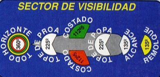
MARINE NAVIGATION LIGHTS

Are those installed on board any type of vessel in order to alert other ships in the area of their presence, reporting capabilities maneuver forward direction and special features for based on a correct identification facilitate maneuvers designed to avoid collisions.

luces_velero

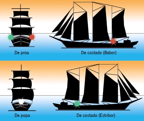
Colors and scope of these lights

  • Forward masthead light aft, is white with an optical range of six miles, 225 ° arc of visibility
    Band light (port) is red, with an optical range of three miles visibility arc of 112.5 °
    Light band (starboard) is green with an optical range of three miles, arc visibility 112.5 °
    Sternlight, it is white, with an optical range of three miles visibility arc of 135 °
    Towing light is yellow, with an optical range of three miles visibility arc of 135 °
    Allround, is white, red color, and green with an optical range of three miles visibility arc of 360 °

sector de visibilidad

papillon chárter

Go ahead and rent your boat with us, do not hesitate to contact, we are at your disposal to inform and boat fare you prefer.

wwwpapilloncharter.com

info@papilloncharter.com            telf. +34 615 629 706    telf. +34 637 843 892

Fuentes:

experienciasdematematicas.blogspot.com
meetup.com
nauticexpo.es
sheratonvallarta.wordpress.com
blogspot.com
disfrutamediterraneo.com
minube.com


APRENDER A NAVEGAR. Alquiler barcos Ibiza.Para los que sois amantes de los barcos y del mar.

Alquile velero Ibiza sunreef dependeIV

Hacemos este post para animaros a que saquéis el permiso de patrón de embarcaciones de recreo, (PER) una magnífica idea para que podáis en cualquier momento alquilar un barco y disfrutar de esta apasionante experiencia como es la navegación.

Es un privilegio poder tener una independencia absoluta, no depender de alguien para que podamos ver sitios tan maravillosos con los que contamos, saber tener el control de un barco y tener la suerte de poder visitar lugares desde el mar, algo que nos ofrece unas vistas diferentes y especiales, verdaderamente todo un lujo.

lagoon-400-alquiler-de-veleros

Las condiciones que regulan las titulaciones náuticas de estas embarcaciones pertenecen a la Dirección General de la Marina Mercante dependiente del Ministerio de Fomento de España. No obstante, las actuaciones a seguir corresponden a las comunidades autónomas que han asumido las competencias en esta materia.

El curso de patrón de embarcaciones es el más demandado por los aficionados a la náutica.

REQUISITOS PARA SU OBTENCIÓN

-Haber cumplido 18 años de edad.

-Superar un reconocimiento médico en centro homologado.

-Aprobar un examen teórico.

-Aprobar el examen práctico o haber realizado las practicas de seguridad y de navegación de al menos 16 horas.

-Efectuar unas prácticas reglamentarias de radiocomunicaciones cuya duración no podrá ser inferior a dos horas, se realizaran en aula, en un simulador homologado de una escuela autorizada.

ATRIBUCIONES BASICAS

Gobierno de embarcaciones de recreo a motor de hasta 15 metros de eslora, que faculta para navegar en la zona comprendida entre la costa y una línea paralela a la misma, trazada a 12 millas de esta.

beneteau-57-alquiler-de-veleros

También podremos navegar entre islas dentro del archipiélago Balear y Canario.

Gobierno de motos náuticas, dentro de los límites específicos de navegación aplicables a estas, de acuerdo con sus características técnicas.

ATRIBUCIONES COMPLEMENTARIAS

Si se realizan las practicas de navegación se podrán gobernar embarcaciones de recreo a motor de hasta 24 metros de eslora, así como navegar entre la península Ibérica y las Islas Baleares.

Si se realizan las prácticas de vela, se podrán gobernar embarcaciones de recreo a vela de hasta 15 metros de eslora, o bien hasta 24 metros si también se han realizado las prácticas de navegación

Oceanis 473 Alquiler de Veleros

EXAMEN TEORICO DE PATRON DE EMBARCACIONES DE RECREO (PER)

La duración del examen será de dos horas y treinta minutos. El test constará de 75 preguntas y la estructura del examen será:

  • Seis sobre tecnología naval.
  • Ocho de maniobras a motor.
  • Once sobre seguridad.
  • Doce sobre navegación (cuatro de ellas sobre ejercicios sobre la carta náutica)
  • Cuatro sobre meteorología.
  • Cinco de radiocomunicaciones.
  • Cinco de propulsión.
  • Quince de reglamentos de abordajes.
  • Cinco de balizamiento.
  • Cuatro de legislación.

Para superar con éxito el examen de esta titulación náutica hay que responder correctamente al 70% de las preguntas, no se podrán cometer más de dos errores en las preguntas de radio, propulsión mecánica , y ejercicios de la carta náutica, balizamiento, y no más de cuatro en el reglamento de abordajes.

PRINCIPIOS BASICOS DE LA NAVEGACION

Las técnicas para mover un barco de un lado a otro se fundamentan en las leyes geométricas y de física mecánica.

Saber posicionarnos en una carta es fundamental, calcular rumbos y direcciones, entender los diferentes modos en que se mide el tiempo, y las diferentes velocidades que se miden en un barco como la SOG, o la COG.

La carta náutica

La carta náutica es una representación a escala de aguas navegables y regiones terrestres adjuntas.

Normalmente indica las profundidades del agua y las alturas del terreno, naturaleza del fondo, detalles de la costa incluyendo puertos, peligros a la navegación, localización de luces y otras ayudas durante nuestros viajes por mar.

Las cartas son un instrumento esencial en las travesías, recientemente hay sistemas informáticos que permiten el almacenamiento y tratamiento de cartas náuticas con ordenadores.

carta nautica baleares jpg

Carta%20mediterraneo.2 jpg

Como os decimos es muy importante saber posicionarse en una carta, para ello se utilizan dos coordenadas, la latitud, y la longitud. Existen muchas posiciones: estimada, Gps, o la posición verdadera, para encontrar nuestra posición podremos utilizar por ejemplo el compás de marcadores.

MANEJO BASICO DEL VELERO

La dirección más fácil a de seguir es la perpendicular al viento, esto es navegar a través.

Hay que situar el barco perpendicular al viento, ir cazando la escota hasta que el extremo de la botavara sobresalga un poco por el espejo de popa y, las velas formen un ángulo con el casco de 45 grados aproximadamente, si lleva foque, colocarlo con el mismo ángulo que la mayor.

NAVEGAR A ESTIMA

Si nos desplazamos según una dirección conocida y también a una velocidad conocida durante un tiempo, podremos estimar una nueva posición y representarla en una carta. En la navegación de estima debemos tener en cuenta las corrientes, también otras desviaciones que podamos conocer para mejorar al máximo nuestra predicción.

Para la navegación de estima es necesario mantener un rumbo lo más exactamente posible, y medir la velocidad que se hace en cada tramo.

OCEANIS-43-alquiler-de-veleros

NAVEGACION ELECTRONICA

Podremos conocer los datos de nuestra navegación de forma precisa gracias a los dispositivos electrónicos, GPS, Chart-plotter, radar, loran, transpondedores y profundímetros.

En el caso que nos puedan fallar los modernos dispositivos; por las estrellas y el sol nos podemos guiar y conocer nuestra posición en el mar.

SOBRE EL FONDEO

En náutica la acción de fondear consiste en amarrar el barco al fondo marino mediante un cabo o cadena ya sea utilizando un ancla o un muerto. Un fondeo con muerto y boya es un dispositivo permanente que permite fondear una embarcación de forma segura.

Los elementos de que se componen son:

  • El muerto, elemento de gran peso hecho de hormigón armado apoyado en el fondo donde se afirma el cabo de fondeo.
  • La línea de fondeo.
  • La boya, objeto flotante que facilita el acceso a la línea de fondeo.
  • La línea de amarre.
  • Los elementos de unión: grilletes y giratorio, estos suelen estar situados en lugar seguro Para fondear, el cual recibe el nombre de fondeadero. Su capacidad de retención es proporcional al peso del muerto independientemente del tipo de lecho, y depende del rozamiento producido con el fondo, cuando el muerto queda semienterrado, el efecto de succión aumenta su fuerza de fijación.

FONDEAR CON VIENTO

En estos casos es necesario sacar cabo que se sumara a los metros de cadena de la línea del ancla. El cabo es conveniente que sea de nylon, es muy resistente y además actúa como muelle por su flexibilidad. Esta flexión permite amortiguar la energía debido a las rachas y golpes de las olas tan frecuentes en un temporal.

No debemos utilizar menos de cinco a seis veces la profundidad en la longitud de la línea total de fondeo, la flexión del nylon eliminará los golpes de tensión en la parte inferior de la cadena, lo cual, ayuda a que este evite el garreo, a pesar de los impulsos repentinos transmitidos por un golpe de ola o una racha de viento.

ANCLAR EL BARCO

Un ancla o áncora es un objeto móvil cautivo náutico que permite a un barco fijar por agarre su posición en el mar sin tener que preocuparse de la corriente, oponiéndose a la fuerza de la marea.

El ancla de fondeo suele constar de dos o más ganchos que son los responsables de que ésta se aferre al fondo marino, impidiendo que el barco pueda ser arrastrado a la deriva. Los barcos pequeños poseen solo una, que está unida a la embarcación por medio de un cabo o cadena, según la eslora y la reglamentación vigente.

Las embarcaciones mayores suelen poseer tres, una en la popa y dos en la proa, enganchadas mediante cadenas.

bahia-de-kleftiko_402259

EL BARCO Y EL MAL TIEMPO

Hay que reducir la superficie de velas para que no peligre la estabilidad de la embarcación debido a la intensidad del viento.

Enrollamos parte del foque en el Stay de proa, o ponemos un foque más pequeño.

Se reduce la superficie de la mayor plegando parte de la vela en la botavara; es lo que se denomina tomar rizos. Si las condiciones meteorológicas son muy malas, una opción es ponerse al pairo, de esta forma el barco quedará parado en el mar y relativamente seguro, debemos de poner proa al viento, este empujará lentamente, así que hay que ver que no tengamos tierra cercana a sotavento.

barco navegando mal tiempo jpg

NAVEGACION NOCTURNA.

Es conveniente que las primeras travesías nocturnas se hagan por lugares conocidos, esto servirá de ayuda para ir aprendiendo a interpretar las distancias. Hay que estudiar detenidamente las cartas náuticas por las que se va a navegar, identificar puntos destacables.

Estando dentro del barco estaremos con la luz de la que disponemos, pues bien, hay que tener en cuenta que cuando salgamos al exterior nuestra vista tardara unos quince minutos en adaptarse a la visión nocturna, por ello se aconseja utilizar la luz roja para que no perdamos del todo esa sensibilidad a la baja iluminación. Disponer de una linterna con luz de color roja nos puede ser de mucha utilidad en algunas ocasiones.

Quedarse dormido por la noche en el barco puede ser muy peligroso, hay que organizar bien las guardias.

Es muy importante utilizar líneas de vida y arneses durante la noche, especialmente viajando solo o en pareja.

velero de noche jpg

LUCES DE NAVEGACION MARITIMA

Son las que se instalan a bordo de cualquier tipo de embarcación con el fin de alertar a los demás barcos en el área de su presencia, informar de las capacidades de maniobra, dirección de avance y características especiales para que en función de una correcta identificación se faciliten las maniobras tendientes a evitar abordajes.

luces_velero

colores y alcance de dichas luces

  • Luz tope de proa a popa, es de color blanca con un alcance óptico de seis millas, arco de visibilidad 225º
  • Luz de banda (babor) es de color roja, con un alcance óptico de tres millas, arco de visibilidad de 112,5 º
  • Luz de banda (estribor) es de color verde, con un alcance óptico de tres millas, arco de visibilidad de 112,5 º
  • Luz de alcance, es de color blanca, con un alcance óptico de tres millas, arco de visibilidad de 135 º
  • Luz de remolque, es de color amarillo, con un alcance óptico de tres millas, arco de visibilidad 135 º
  • Todo horizonte, es de color blanco, roja, y verde, con un alcance óptico de tres millas, arco de visibilidad de 360 º

sector de visibilidad

papillon chárter

Anímate y alquila tu barco con nosotros, no dudes en contactar, estamos a tu disposición para informarte de tarifas y del barco que prefieres.

wwwpapilloncharter.com

info@papilloncharter.com            telf. +34 615 629 706    telf. +34 637 843 892

Fuentes:

experienciasdematematicas.blogspot.com
meetup.com
nauticexpo.es
sheratonvallarta.wordpress.com
blogspot.com
disfrutamediterraneo.com
minube.com


Este sitio web utiliza cookies para que usted tenga la mejor experiencia de usuario. Si continúa navegando está dando su consentimiento para la aceptación de las mencionadas cookies y la aceptación de nuestra política de cookies, pinche el enlace para mayor información.plugin cookies

ACEPTAR
Aviso de cookies
Call Now ButtonLlámanos
× WhatsApp